Getting started with spatial data
The Informix® spatial solution embeds a geographic information system (GIS) within the Informix® database server. The Informix® spatial data types integrate spatial and non-spatial data, providing a seamless point of access using SQL (Structured Query Language).
Informix® spatial data types implement the OpenGIS Consortium, Inc. (OpenGIS, or OGC) SQL3 specification of abstract data types (ADTs). These data types can store spatial data such as the location of a landmark, a street, or a parcel of land. Informix® spatial data types also conform to the OpenGIS Simple Features Specification for SQL Revision 1.1 and the ISO/IEC 13249-3 SQL/MM Part 3: Spatial. The Informix® Spatial solution is based on the ESRI SDE 10.2 Shape and PE libraries.
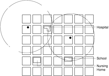
You use the ST_Overlaps() function to evaluate whether the polygon that represents the building footprint of the school overlaps the circular polygon that represents the 5-mile radius of a hazardous waste site. The building footprints of the school, hospital, and nursing home are stored in the ST_Polygon data type and the location of each hazardous waste site is stored in an ST_Point data type.